Google Maps Now Lets You Take A Virtual Boat Ride Down The Amazon
Share

I am continually surprised at the extent to which Google Maps cameras have travelled to bring us street views from so many places along the paved world. Just last year they took us on a train ride through the Alps, now they’ve gone where no car or train can go: the Amazon rainforest.
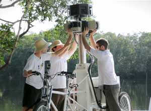
Google partnered with the Amazonas Sustainable Foundation (FAS), a local non-profit dedicated to preserving the Amazon. They traveled to the Amazon Basin last August and captured more than 50,000 images which were then stitched together to produce 360-degree, panoramic views of the Amazon. For those of us who will never have the chance to visit the world’s largest rainforest, Google Maps gives us the next best thing. You can take a virtual boat ride down the Rio Negro river or pass deeper along tributaries into a flooded forest. You can visit Tumbira, the Rio Negro Reserve’s largest community or take a hike down an Amazon forest trail and see Brazil nuts scattered across the forest floor, ready to be harvested. You can even have a close-up encounter with a local frog, although I don’t think the Google camera lens is part of their natural habitat.
Be Part of the Future
Sign up to receive top stories about groundbreaking technologies and visionary thinkers from SingularityHub.

Peter Murray was born in Boston in 1973. He earned a PhD in neuroscience at the University of Maryland, Baltimore studying gene expression in the neocortex. Following his dissertation work he spent three years as a post-doctoral fellow at the same university studying brain mechanisms of pain and motor control. He completed a collection of short stories in 2010 and has been writing for Singularity Hub since March 2011.
Related Articles

This Portable Wind Turbine Is the Size of a Water Bottle and Charges Devices in Under an Hour

Mojo Vision’s New Contact Lens Brings Seamless Augmented Reality a Step Closer
The Weird, the Wacky, the Just Plain Cool: Best of CES 2020
This Portable Wind Turbine Is the Size of a Water Bottle and Charges Devices in Under an Hour
Mojo Vision’s New Contact Lens Brings Seamless Augmented Reality a Step Closer
The Weird, the Wacky, the Just Plain Cool: Best of CES 2020
What we’re reading