Quadcopters Make 3D Scans Of Historic Buildings

Share
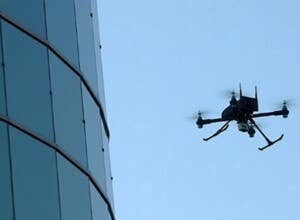
Humans continue to make their lives easier with drones. Small-sized unmanned aerial vehicles (UAVs) are already chasing after wanton criminals, inspecting contaminated power plants, even bringing us our order of delicious tacos. Now researchers at the University of Granada’s Department of Programming Languages and Computer Systems wants them to scan historical buildings and other points of interest so that they can be reproduced virtually in 3D.
For a job that would otherwise require large, costly, and risky cranes, the quadcopters will be equipped with stereoscopic cameras and distance sensors and will be able to reach places tough for a crane to get to. They will be able to fly within inches of the building surface or monuments to capture high-definition detail. The 2D images, which are geopositioned for precise location, will then be stitched together to create 3D representations.
The quadcopters are flown by controllers at the moment, but the team hopes someday to make them fully automated – just designate a structure and wait for the data. Right now, if a copter’s battery runs low the operator will guide it down for a landing and change the battery. Still, much easier than operating a crane or being lowered on a scaffold. Two quadrocopter versions are being tested, a “standard version,” supplied by Intelligenia Dynamics, and a modified version with better control.
At the moment the project is proof-of-principle to show that 3D architectural measurements with quadcopters are quick, cheap, and easy. There’s no indication yet what the 3D renderings will be used for, but using 3D printing to create models is an obvious application, as Autodesk is already doing. Or, seeing as they’re focusing on historic landmarks and monuments, maybe they want to give potential Granada visitors a virtual tour that will take their breath away.
Be Part of the Future
Sign up to receive top stories about groundbreaking technologies and visionary thinkers from SingularityHub.


[image credits: University of Granada]
[video credit: Intelligenia Dynamics via YouTube]
images: University of Granada
video credit: Intelligenia Dynamics
Peter Murray was born in Boston in 1973. He earned a PhD in neuroscience at the University of Maryland, Baltimore studying gene expression in the neocortex. Following his dissertation work he spent three years as a post-doctoral fellow at the same university studying brain mechanisms of pain and motor control. He completed a collection of short stories in 2010 and has been writing for Singularity Hub since March 2011.
Related Articles

Scientists Want to Give ChatGPT an Inner Monologue to Improve Its ‘Thinking’

This Robotic Hand Detaches and Skitters About Like Thing From ‘The Addams Family’

Humanity’s Last Exam Stumps Top AI Models—and That’s a Good Thing
What we’re reading
