The Future of Maps: 3D, Realtime, and Totally Personalized
Share
What's the feature on my iPhone that I use the most? It's not games, nor music, nor texting...not even calling. The tool I use most often on my smart phone is the map. And it's not just because I'm prone to get lost and need directions. I'm also looking for good places to eat, checking on traffic and travel times, and geo-tagging photos. Online maps have become an indispensable part of our world, and they're only going to grow in importance in the years ahead. They are getting upgraded in detail, with 3D layouts, advanced terrain, and better street view images. And we're filling these richly drawn maps with tons of media: videos, photos, wiki articles, critical reviews, and status updates. The future of maps is going to merge the digital and real worlds in a way that makes them even more central to the way we live. Here's how.
Maps Go 3D
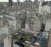
If you haven't downloaded the Google Earth plugin, please do so. While you're at it, go visit Bing with IE or Firefox and download their 3D mapping file too. Got 'em? Good. These two maps, with all their 3D flashiness, are at the forefront of making virtual geography more realistic. Using aerial photography and some pretty amazing photo-stitching programs, Google and Microsoft have devised ways of taking two dimensional pictures and bending them into a 3D virtual world. The effect is a little weird looking (like playing a real-world version of Doom) but it gives you the sense of the actual height and depth of the area you're exploring in the map. As an avid apartment searcher, these 3D maps give me a much better sense of the neighborhood and feel of a perspective home. Even with a skewed view, three dimensional images just make you feel more present in a map.
Of course, these 3D dimensional distortions don't come cheap, computationally speaking. It takes some major processing mojo to dynamically move through a 3D rendered environment formed from thousands of 2D photos. An alternative, which potentially uses less computing power, is to have 3D maps drawn from vectors. Several companies are pursuing that approach, with UpNext being one of the better examples. UpNext gives you a very life-like 3D model of a city that easily resizes and tilts as you explore the map. It's available on your iPhone, but only in a few select locations.
Whether it's with photo-stitching or vector rendering, 3D perspectives pull you in. Such techniques solve one of the bigger limitations of maps - letting you know what things will actually look like to you when you get to the place your looking for. When 3D maps really get into full swing, with higher detailed images and more processing power behind them, exploring them will be like exploring the real world.
But 3D maps require a lot of capital to create at the moment, meaning you'll only have a few (coporately sponsored) views of a location. Which is why futuristic maps are already starting to include...
Crowdsourced Media
Why let Microsoft and Google show you the world, when all your friends on Facebook can give you a much more personal view. With geo-tagging (linking data with a geographic location), photos can be placed directly on a map exactly where they were taken. Videos, too. Google Maps has become inundated with the camera-droppings of thousands of users who are uploading their media directly onto the maps. Go to the 'more' button in Google Maps and check the boxes for videos and photos. It's crazy. You can see directly into someone's record of an event, and know exactly where it happened.
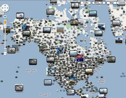
It's not stopping there. Instead of looking at memories, we're going to start looking at what's actively happening in realtime. As we saw in Blaise Aguera y Arcas' TED presentation, Bing is working on including live video feeds from users in the field. Such technology is still in early development, and there currently aren't many people constantly uploading video feeds of their lives. Eventually, however, such realtime video could completely blanket densely populated urban areas. You could log on to Bing and not just see a 3D map of the world, you could see what was actively happening in any location you wanted. That's just nuts...and it's coming fairly soon.
Of course, one of the most interesting aspects of this explosion of mapped media is that it is driven almost entirely by users. Google and Microsoft aren't going to pay millions of people to take photos and geo-tag them. We're going to do that ourselves. Why? The same reason we share photos on Facebook. Social media is addictive, and it builds this non-traditional sense of community where loved ones can be very distant from you but still actively involved in your life. Alternatively, completely anonymous people can affect your life because they share your location and interests. Which brings us to...
Be Part of the Future
Sign up to receive top stories about groundbreaking technologies and visionary thinkers from SingularityHub.

Everyone's A Critic
Along with photos and videos, geo-tagging has brought about a new way of vetting restaurants, shops, and venues. Programs like Yelp let you add your opinion into a database of criticism and praise. I just go to the Yelp map, and let it not only tell me what's around but which places are ranked as the best deals. Forget traditional food columnists in newspapers, when I want know which new restaurant to try I look up scores on Yelp. It's peer-reviewed food. Same for shops, music hotspots, even dentists.
Smart phone applications like FourSquare, Gowalla, and Booyah add in an element of gaming. Do you like the noodle house near your work? FourSquare lets you check-in and get points every time you go there. Go there enough and you become the mayor of the restaurant. Gowalla has a similar system, and Booyah lets you outright 'own' a virtual copy of the place. Along with virtual points, these applications can give you real-world prizes (free food and drink are common) when vendors play along to draw interest.
These companies (and many others) are finding ways to harness user opinions by tying them down to maps. Advertisements, featured links, and give-away deals provide means for them to generate revenue while you and I create all the content. Crowd-sourcing media is a great idea, but it's these crowd-sourced experiences that are becoming really addictive. The truth is that most of us don't always know how to decide which car rental place to use, which bar to visit, and which attorney to represent us for drunk driving. But Yelp knows. It's like having thousands of semi-anonymous friends giving you advice all at once. Scary but awesome.
More and More Layers To the Cake
Why stop at 3D renderings, media, and opinions - there's so much more that can fit on a map. And it looks like we're going to cram in everything we can. Real estate? Google Maps has it directly on the site and specialists like PadMapper and HousingMaps provide slightly tweaked and filtered versions to make your house-hunting easier. Wikipedia? The encyclopedia anyone can edit now has many articles linked to the real-world locations they correspond to, just look for the "coordinates" at the top right of the page. Again, Google let's you see these directly on their maps. News? Companies like Fwix are giving you local news and showing exactly where it happens. Crime? Dozens of agencies, like CrimeReports, display publicly released statistics about law infractions of all kinds. Is there something else you want to add into a map? Well, create your own. Personalized maps in Google let you add icons and drop them onto locations and then share your newly labeled world with others. Open Street Map is an open source project that lets you edit the map itself.
As more and more layers are added to maps, you'll be able to customize what you see when you want to see it. Need to know which nightclub is bumping right now? Live video feeds will give a picture while apps like FourSquare will tell you which people are there. Want to take a virtual tour through wine country? Turn off all the layers and just enjoy a 3D stroll through the map. Eventually we'll be able to set alerts (just as we can do with search results) and you'll get traffic, crime, and news updates relevant to the places you live and travel. Personalized and dynamic maps are going to be amazing and they're already halfway here.
As more people use and share information through them, advanced maps will become even more powerful. You'll be able to see what a place looks like through the multi-faceted insect eyes of social media, and use that insight to plan how you yourself would like to travel and interact. Right now there are still geographic frontiers this technology has yet to cross (street views of Silicon Valley are a lot easier to get a hold of than Mozambique) but the prevalence of mobile phones will change that. In a decade just as the internet lets us learn about any thing, internet maps will let us learn about any where. The world will really be at our fingertips.
[image credits:Google, Bing]
[video credits: UpNext, Howcast]
[source: Google, Bing, UpNext]
Related Articles

Hackers Are Automating Cyberattacks With AI. Defenders Are Using It to Fight Back.

Thousands of Everyday Drone Pilots Are Making a Google Street View From Above

Scientists Send Secure Quantum Keys Over 62 Miles of Fiber—Without Trusted Devices
Hackers Are Automating Cyberattacks With AI. Defenders Are Using It to Fight Back.
Thousands of Everyday Drone Pilots Are Making a Google Street View From Above
Scientists Send Secure Quantum Keys Over 62 Miles of Fiber—Without Trusted Devices
What we’re reading