Blaise Aguera Demos Amazing Dynamic and Augmented Reality Maps (Video)
Share

Expect more from your maps. Blaise Aguera y Arcas, the mind behind Sea Dragon's revolutionary approach to photo images, is ready to update maps for the 21st century. Now working for Bing, Aguera
gave a remarkable presentation at TED this year, demonstrating how that company's maps would soon be breaking boundaries of space and time. New layers of digital information would be superimposed over the visual images of streets and sites, providing an augmented reality experience. Just as promising, Aguera gave a sneak peak at how live video could be incorporated - giving a real-time view of what was happening at a location. All of these features will be available from the same interface. Aguera's vision for the future of maps is too incredible to miss, check it out in the video below.
The utility of maps has made them one of the most often used features of smart phones. With information from Yelp, FourSquare, Twitter, and a thousand other apps, it's like you're carrying around a portal into the digital realm. That portal could help you find a good place to shop, or it could help save your life when combined with vital information for emergencies from companies like Civi-Guard. No matter how it is used, looking at that meta-data and overlapping it with the real world is augmented reality at its finest. We've already seen how other AR developers (like Layar) are jumping into combining the technology with maps. In other words, it should be no surprise that Bing Maps is melding AR with maps, or that they dedicated Aguera's considerable talent to the project. Maps are the perfect interface between the physical and digital worlds. And they're big business because everyone wants to use them.
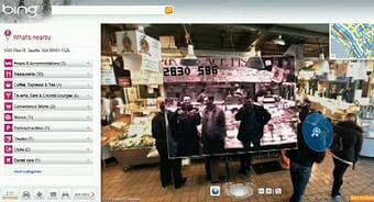
At just over 8 minutes, Aguera's presentation is short enough for you to watch the entire thing, and cool enough for you to want to catch every second. If you must skip around make sure to catch the ultra-smooth zoom from traditional map to ground images (2:15), the inclusion of Flickr images (~3:00), the inclusion of indoor images (~4:00), the first ever live demo of video integration (4:45), and some cool use of sky maps/telescope images (7:00).
Be Part of the Future
Sign up to receive top stories about groundbreaking technologies and visionary thinkers from SingularityHub.

As amazing as it appears, a large portion of what Blaise Aguera y Arcas demonstrates in his presentation isn't exactly new. I'm not sure if you've been delving deep into Google Maps lately, but you can perform many of the same feats there as those seen in the video above (shared photo images, overlapping meta data with real world views, 3D city maps). Also, while the crisp transitions between images is very nice, Aguera first showed us this capability in his 2007 TED Talk on Photosynth and Sea Dragon.
To me, the real eye-openers of this presentation were definitely the live video streamed over the 4G network, and the capability of layering even more meta data on the map. Video and improved AR - these are game changers when it comes to the next generation of maps. At some point, with enough people and businesses constantly filming their surroundings, we can expect most public places to have associated live video. You may eventually be able to sit in your home and see what is happening in exactly the location you are interested in. Then, when you are on the go, AR overlays will provide an unprecedented way of interacting with your surroundings. Don't just look at what you see, look at the history of a place, people's attitudes about a place, your favorite memories of a place - all at the same time. These capabilities are coming, and you're going to want them. Trust me.
For now, things are fairly limited. I've been to Bing Maps to play around. Definitely some cool things going on there, but we've yet to reach the real-time video and AR mecca that I envision we could have some day. Check out their overlap of Flickr images (you'll have to find a very famous or often used space for a chance at success), and the wide assortment of "map apps". Good stuff there.
One day, the merger of digital information and location images (i.e. maps) is going to be complete, and it's going to rock our world. Consider all the data that will be streaming in from the upcoming Internet of Things. Your maps will show you all you want to know about a space, and every thing of importance that's ever been in it. Find a cab in real time, track pollution, locate your kids all from your smart phone as you walk around. Augmented reality will let you see it all right on the map. Aguera has the right idea, and I can't wait until Bing, or Google, or someone else brings it to life.
[screen capture and video credit: TED]
[source: Blaise Aguera y Arcas via TED, Bing Maps]
Related Articles

Europe Approves Bionic Eye to Restore Vision Lost to Blindness

OpenAI Agent Breaks Free and Hacks Hugging Face

Orbital Data Centers Are Seductive on Paper, but They Face Daunting Challenges in Reality
Europe Approves Bionic Eye to Restore Vision Lost to Blindness
OpenAI Agent Breaks Free and Hacks Hugging Face
Orbital Data Centers Are Seductive on Paper, but They Face Daunting Challenges in Reality
What we’re reading