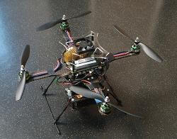
What’s the old saying – tell a robot where to fly and you help it for a day, teach a robot how to fly itself and you help it forever? Something like that. Engineers on the PixHawk project at the Swiss Federal Institute of Technology in Zurich (ETH) have developed a quadrotor flying robot that uses computer vision to guide itself while it flies. The four bladed drone (the PixHawk Cheetah) can be equipped with one to four onboard cameras that track special markings on the ground to locate itself and navigate. PixHawk has made the Cheetah quadrotor computer vision compatible with the open source Robot Operating System (ROS) library, creating the possibility that other quadrotor and drone developers will be able to incorporate these navigation techniques into their own designs and vice versa. Watch the robot demonstrate its stability and tracking in the two videos below. It’s awesome to see a flying robot drive itself.
The PixHawk Cheetah’s greatest attribute is clearly its ability to orient and navigate based on what it sees. In the first video, notice how it easily recovers from being pushed around, and how it can track and follow an object (the orange ball on a stick). The second video gives you a better idea of how the Cheetah can combine computer vision orientation with advanced mapping techniques to allow it to autonomously fly on a longer course.
I’m excited after seeing the PixHawk Cheetah in action and knowing that its computer vision capabilities are now going to be freely available via ROS. I’d love to see some of this autonomous marker-based flight incorporated into other quadrotors we’ve seen. The Cheetah isn’t the most badass flying drone (that would be the window jumping quadrotor from UPenn) nor is it likely the most fun (Parrot’s AR Drone has that covered), but it does have the most to offer. It has a completely onboard navigation scheme that could allow the flying drones of the future to function with little to no guidance. That could have big applications for military spy drones. The PixHawk team is already working on pattern recognition and computer vision techniques so that those little markers on the floor could one day be replaced by real-world objects and images. Eventually all you’ll need to do is upload an aerial map of an area, tell a quadrotor to patrol, and it will nagivate around and take real-time images it can transmit back to home. Teach a robot drone how to fly itself and it will spy on you for a lifetime.
[image credits: ETH
[source: ETH]


